3-15-2014: Anchored out in the beautiful, clear blue water by Manjack Cay, Abaco, Bahamas

Friday, November 12, 2010

Wednesday, November 10, 2010

Happy Birthday to the USMC - 235 years old.  When we got to Eastern Shores Marina I took the CO out to dinner to celebrate his birthday.  The waitress said that he didn't look 235!  We had excellent sea food at Tamra's in downtown Fairhope, AL.

We got an early start to our 70 mile day; 06:20 with some fog but OK to go.  We heard from Sea Hawk this morning at Mile 15 and the tide of about 1 foot got him off ground at 01:30.  He thinks all is well but will have everything checked at Mobile Bay.

We made it through Mobile Bay and turned at Marker 72, 90 degrees for 1 mile and then 125 degrees for 6.5 miles to our marina.  When we turned at 72 our depth was only 4 feet (low tide); a little nerve racking but we made it just fine.  It sounds like we will be here for a while as we have to wait for parts for our cutters.  We did have a damaged prop and we are having our spare props put on.

N30 32.549
W87 54.140

CO's comments:  Some people had made the comment to me-why do you need radar on the river?  That is one piece of equipment that I would not be without.  In fog with visibilities of 1/4 mile you could not only pick up other boats but buoys, deadheads and the shoreline.

Lots of birds on the river

Sea Hawk on the water again
Our first view of Mobile Bay
Off loading a container ship
Mobile Convention Center
Roy El leaving anchorage-decided to bring a tree with

Thursday, November 11, 2010

Tuesday, November 9, 2010

Another long day and another foggy morning so getting up early didn't help us.  We went through Coffeeville Lock first thing and for the first time in a long time things went smoothly and fast.  From here on out the tides will be in effect.  This was our last lock until we cross the gulf and enter the Okeechobee Waterway in southern Florida; YEA!

We met 10 Tows today; couldn't believe how busy it was.  At Mile Marker 96.5 a doe and her fawn swam across the river right in front of us.  I didn't have time to get my camera but it was pretty cool to see.

At Mile Marker 58 we met Sea Hawk, a 65' Jefferson, who was hard a ground.  He said he wasn't paying attention when he came around the corner and there was a green buoy out of place and he just headed toward it without looking at his GPS and right into shallow water he went.  He said he hopes that the 2 ' tide that should be here about 01:00 will help him off.  Otherwise, Dog River Marina from Mobile Bay will get him in the morning.  At least he is out of the channel but he will have to stay awake and warn boats/tows that he is there.

N31 11.510
W87 56.618

CO's comments:  On any waterway if you do not pay attention where you are going at all times you will end up hitting, remember the rivers are ever changing.  I am sure Sea Hawk will have to have his boat lifted out of the water and have his props and shafts checked.

Early morning for at Alabama Cut-Off  Mile 52.8
Tombigbee River so smooth you can see reflections of the trees

Monday, November 8, 2010

Gas Dock at Bobby's Fish Camp

Bobby's Fish Camp


We had a short day so we slept in and got going about 08:45.  It was another beautiful day.  The river was smooth as glass and I got some nice pictures with reflections on the water.

Anchorage at Turkey Creek, Mile 120.7
Stopped at Bobby's Fish Camp.  It was like something out of the 1950's; like you went back in time.  It is my understanding that "Bobby" is buried right out in front of the camp.  When I called to see if someone could come down to the dock and help me with my lines they said yes and when we got there he sat on his porch, drank his pop, and just watched us.  You even had to pump your own gas.  If you dock there for the night you pay a $1.00 per foot for nothing but the tie-up; no electric or water.  We chose to anchor out at Turkey Creek, Mile 120.7 for free.  It was a beautiful anchorage.

CO's Comments:  When docking at a old dock such as Bobby's and to get tied up properly you need a good deck hand and I have got one.

N31 47.377
W88 10.024

Sunday, November 7, 2010

Last night we changed back to Standard Time so we set our alarm for 05:00 so we could get an early start in the morning because we had a 69 mile day.  We woke up to very foggy and cold morning; 35 degrees and there was a thin coat of ice all over the front of the boat.  We did not get going until 07:30 and didn't get through the lock until 09:00; so much for an early start.  When I was out in front going through the lock I was slipping and sliding on the ice.

We met our first Tow at Mile Marker 198.5 and passed him at 3700 RPM's.  Keith said at 3300 RPM's we started to shake due to our problems from the other day.  When we get to Mobile Bay we have an appointment to have the boat pulled and checked; he thinks we probably bent one of the props.  We were planning on pulling the boat anyway to have cutters put on the prop shafts to cut away any crab pods we might get tangled in.

It turned out to be a beautiful, warm day.  I have been told that after leaving Demopolis, AL, that we are entering "Deliverance" country; scary!  We met 5 to 6 Tows today, other than the Tows there wasn't any other boats on the river which surprised us.

We have been anchoring each night with Roy El and taking turns with the evening meal.  So every other night I don't have to cook or do dishes.
Demopolis Dam
Going into anchorage at Mile 145
Bashi Creek, AL
Rafting at Bashi Creek with Roy El
CO's comments:  I think what I hit the other day was a metal piling that had fallen into the anchorage area.  It was certainly metal on metal.  Will take it easy and get the problem fixed at Eastern Shores Marina in Mobile Bay.  Just because the first boat into an anchorage or tie-up does not have a problem does not mean that you may not.

N31 57.3603
W88 04.2743

Saturday, November 6, 2010

Last nights anchorage was at Port Epes, AL, Mile 247.0; bad idea.  We hit something twice on the way in.  We don't know if there is any damage or not.  Will have to wait  and see when we get going in the morning.

We had some fog this morning but not too bad so we got an early start; 07:20.  So far so good as far as any damage done during yesterday's anchorage.  The Tenn-Tom is nothing like I had envisioned.  I thought we would be wearing shorts and have the top down on the boat but instead, we are wearing winter jackets, gloves, and we still are cold. The last 2 nights in got down to the low 30's.  We did not have any locks today and it is a good thing because the wind is still pretty strong.  We stopped at Demopolis Yacht Basin for fuel, pump-out, water, mail, and my prescriptions.  We then went to Foscue Creek, AL, and tied up to an old barge at the Coast Guard Station with Roy El.  We got the wrong instruction's going in and almost hit something again.  This is getting hard on me.

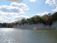
White Clifts of the Tenn-Tom
Coast Guard Wedge at Port Epes tie-up
Tie-up at Port Epes, Mile 247.0
At Mile Marker 217.0 the Tenn-Tom officially ends and the Tombigbee River/Lower Black Warrior River begins.  This also starts Phase 6 of our Loop experience.

N32 30.872
W87 52.554